

The dawn of the low-altitude economy marks a profound shift, positioning airspace as humanity’s “fourth economic space.” This emerging domain—from autonomous drone logistics and urban air mobility to advanced aerial inspections—is redefining our relationship with three-dimensional space. Yet realizing its full potential depends on one critical enabler: scalable, computable, real-time digital spatial infrastructure to orchestrate this complex aerial ecosystem.
The Unseen Frontier: Navigating 3D Airspace Challenges
Nations worldwide are racing into this frontier. China eyes trillion-dollar growth, Japan prioritizes rural logistics, the Middle East invests in vertiports, and the West emphasizes strict regulations. Despite varied strategies, one universal challenge persists: building a safe, viable, real-time 3D airspace system.
The solution lies in advanced 3D Geographic Information Systems (GIS) and digital twin technologies. But low-altitude operations bring unprecedented hurdles:
- Massive data volumes—centimeter-level 3D city models, real-time weather, dynamic airspace rules, and obstacle maps—demand instant processing beyond traditional hardware.
- Cross-device access requires seamless, high-performance interaction for command centers, field units, and autonomous systems with consistent visuals and computation.
- Data security vs. collaboration: sensitive geospatial info must stay centralized and leak-proof while enabling real-time decisions across stakeholders.
- Agile, cost-effective deployment conflicts with expensive local high-performance rendering.
The real bottleneck? Not creating 3D GIS, but operationalizing it globally, securely, and scalably.
Cloud XR Streaming: The Digital Nervous System of the Skies
Cloud XR Streaming transforms this landscape. By offloading intensive rendering and computation to the cloud, it delivers interactive, high-fidelity 3D content to any device, anywhere, with ultra-low latency. This frees low-altitude operations from local hardware limits, enabling true spatial intelligence.
Key benefits include:
- Real-time rendering of vast 3D environments, surpassing physical compute constraints.
- Consistent access across devices—from mobiles and XR headsets to command displays.
- Data sovereignty: sensitive info stays cloud-secure, with only encrypted visuals streamed to endpoints.
- Real-time multi-user collaboration for synchronized team decisions.
Leading this revolution is Paraverse’s LarkXR—a mature, commercial Cloud XR Streaming PaaS. Built for demanding 3D visualization like low-altitude GIS, it forms the core spatial computing layer for next-gen apps.
“Aerial Gaode”: A Global Benchmark for Low-Altitude Operations
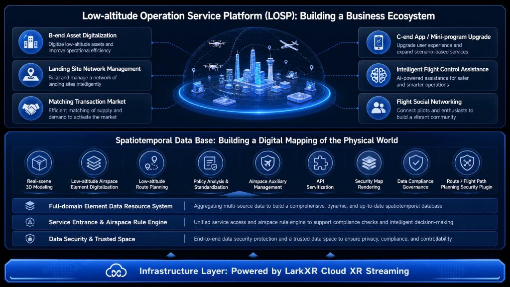
The strategic partnership between Gaode Map (Amap) and Paraverse, culminating in “Aerial Gaode,” stands as a compelling testament to the power of Cloud XR Streaming, extending mapping into airspaceas as a unified low-altitude OS for governments, enterprises, and end-users worldwide.
Built on spatiotemporal foundations blending real-time low-altitude 3D data with ground GIS, it uses AI-driven reconstruction—implicit modeling and deep learning—for near-daily, high-quality 3D maps at lower costs. Core features: airspace management, dynamic path planning, real-time events, and collision warnings.
LarkXR powers its Cloud XR backbone for high-demand reliability:
- Cloud-Native Digital Twin: LarkXR clusters manage the real-time rendering of city-scale 3D models, dynamic airspace information, and meteorological layers, streaming high-fidelity visuals with ultra-low latency.
- High Concurrency / Low Latency: It supports thousands of concurrent users—pilots, dispatchers, regulators—requiring millisecond-level response times for critical flight planning and monitoring.
- Ubiquitous Access: Ensuring that all stakeholders, regardless of their device or location, share the same synchronized, high-quality aerial situational awareness.
- Data Security: Sensitive data remains securely in the cloud, with end-terminals receiving only encrypted video streams, thereby eliminating local data exposure risks.
- Accelerated Innovation: Platform updates and new 3D data are deployed once in the cloud, instantly propagating to all users, significantly streamlining business iteration and development cycles.
Paraverse: Architecting the Future of Low-Altitude Visualization
LarkXR is a commercially proven Cloud XR Streaming PaaS defining a new paradigm for low-altitude visualization.
Paraverse, through LarkXR, acts as a pivotal enabler, constructing a critical component of the digital infrastructure for the low-altitude economy. It addresses industry-wide pain points by:
- Democratizing Access: Slashes terminals and IT costs.
- Digital Trust: Meets the stringent data security and compliance needs.
- Operational Excellence: Delivers professional-grade 3D across all terminals for efficiency and safety.
- Innovation Boost: Speeds the development, deployment, and iteration of low-altitude applications.
Compatible with GIS (SuperMap, Cesium), 3D engines (UE/Unity/proprietary), and low-altitude devs, LarkXR fosters ecosystem growth.
The Cloud-Powered Horizon: A Trillion-Dollar Vision
Low-altitude prosperity hinges on intuitive 3D visualization—its “eyes and brain.” Paraverse LarkXR bridges compute gaps, fixes security risks, and enables cross-platform access via cloud rendering.
Proven in “Aerial Gaode,” it scales from pilots to global ops. As commercialization accelerates, LarkXR empowers partners for intelligent, secure 3D airspace. In this trillion-dollar market, cloud-powered 3D GIS claims first-mover urban skyline control.